When we think about the future of our cities, our minds often gravitate towards striking architecture, advanced transport networks, or sprawling public parks. However, one of the true driving forces behind how a city functions, grows, and evolves is largely invisible to the naked eye. It is encoded in thick municipal rulebooks, complex maps, and strict legal frameworks. Land use and zoning regulations serve as the foundational blueprint of urban life. They dictate what can be built, where it can be built, how tall it can stand, and what purpose it can serve.
As the global population increasingly gravitates towards urban centres, the way we manage this limited spatial resource will determine the economic vitality, functional efficiency, and overall livability of our future cities. To understand how cities will look and operate in the coming decades, we must first examine the powerful levers of land use and zoning, weighing their distinct advantages against their unintended consequences, and exploring how these systems can be modernised for the future.

Understanding the foundation of urban planning
At its core, zoning is the process of dividing land in a municipality into designated zones in which certain land uses are permitted or prohibited. The most common system, historically referred to as Euclidean zoning, categorises land into distinct, single-use areas. These typically include residential, commercial, and industrial zones, which are often further subdivided by density – for example, low-density residential zones restricted to single-family detached homes versus high-density zones that allow for towering apartment blocks.
Land use regulations go hand-in-hand with zoning, governing not just the functional purpose of a site, but its physical parameters. These regulations dictate setbacks (how far a building must be from the street or property line), floor area ratios (the relationship between the total floor area of a building and the size of the land it sits on), maximum building heights, and minimum parking requirements.
Together, these rules form a highly prescriptive matrix. They were originally designed in the late 19th and early 20th centuries to bring order to rapidly industrialising cities. By separating noxious factories and heavy industry from residential neighbourhoods, early urban planners sought to improve public health and safety. Over time, however, these regulations have expanded far beyond keeping slaughterhouses away from houses, evolving into complex mechanisms that micromanage almost every aspect of urban development.
To truly grasp how these frameworks operate, it helps to distinguish between the long-term vision of a city and the immediate rules on the ground. As Keith Cooke, from ESRI, elegantly summarises in episode 434I on the What is the future for cities? podcast:
The distinct advantages of land use regulation
Despite the criticisms often levelled at bureaucratic planning systems, there are compelling reasons why virtually every major city on the globe relies on zoning and land use regulations. These frameworks provide essential benefits that maintain urban order and protect investments.
First and foremost, zoning provides predictability and stability for property markets. Real estate is fundamentally driven by certainty. When a developer purchases a plot of land for a commercial high-rise, or a family buys a suburban home, they do so with the confidence that the surrounding properties will not suddenly be converted into incompatible uses, such as a noisy manufacturing plant or a sprawling logistics facility. This certainty protects property values and encourages long-term investment in the built environment.
Secondly, land use planning is critical for efficient infrastructure deployment. Delivering utilities – water, electricity, sewerage, and telecommunications – as well as constructing roads and public transport networks requires massive capital expenditure. When a city can accurately predict where heavy industrial power users will be located, or where high-density residential populations will cluster, authorities can dimension and route infrastructure with precision. Without a coordinated plan, cities would face chaotic utility demands, leading to overloaded power grids, congested roads, and failing sewerage systems.
Furthermore, zoning regulations protect public health and safety. Even in a post-industrial service economy, there remains a necessity to separate incompatible activities. Restricting high-traffic commercial hubs to specific corridors keeps heavy vehicular traffic out of quiet residential streets, reducing accident risks and noise pollution. Regulations regarding building heights and setbacks ensure that natural light and airflow can reach street levels, preventing the creation of dark, unhealthy urban canyons.
Finally, these regulations serve to protect the historic and architectural character of neighbourhoods. Heritage overlays and design guidelines ensure that new developments respect the scale and aesthetic of existing historical districts, preserving the cultural and architectural history that gives global cities their unique identities and tourism appeal.
The significant drawbacks of rigid zoning
While the benefits of an ordered city are clear, the rigid application of traditional zoning has generated profound negative consequences that threaten the future viability of many urban centres.
The most glaring drawback is the facilitation of urban sprawl and extreme car dependency. By legally mandating the separation of where people live, work, and shop, traditional zoning forces residents to travel significant distances to fulfil basic daily needs. This single-use paradigm has birthed sprawling, low-density suburbs that consume vast tracts of arable land and require massive, expensive road networks. This spatial inefficiency leads to severe traffic congestion, massive economic losses due to time spent commuting, and immense fiscal burdens on local governments struggling to maintain sprawling infrastructure networks.
Additionally, rigid zoning is frequently identified as a primary driver of housing shortages and the resulting affordability crises seen in major cities globally. In many municipalities, vast majorities of residential land are exclusively zoned for single-family detached homes, legally prohibiting the construction of townhouses, duplexes, or mid-rise apartments. By artificially capping the supply of housing and limiting density, these regulations create a severe mismatch between supply and demand. As urban populations grow, the competition for a artificially limited number of dwellings drives property prices and rents to unprecedented heights, severely dampening economic mobility and consumer spending power.
Moreover, overly prescriptive land use regulations stifle economic innovation and adaptability. The modern economy is highly dynamic; the distinction between a home, an office, and a small-scale manufacturing space has blurred with the rise of remote work and digital fabrication. Yet, rigid zoning categories remain stuck in the past, making it illegally complex for entrepreneurs to open small businesses in residential areas or for developers to quickly adapt empty office buildings into residential apartments during economic shifts.
The sheer complexity of the regulatory framework also acts as a barrier to entry. Navigating the bureaucratic red tape required to secure planning permission often takes years and millions of dollars in holding costs and consultancy fees. This heavily favours massive, well-capitalised development corporations at the expense of small-scale builders, leading to a homogenised urban landscape and slower responses to market demands.
This link between strict zoning and soaring property prices is ultimately a matter of simple supply and demand. Speaking in episode 434I on the What is the future for cities? podcast, Keith Cooke notes that restrictive zoning is a key reason many metropolitan areas are underproducing housing. “Affordability and capacity are almost always tied together,” Cooke explains, pointing out that while affordability can sometimes be a politically charged term, focusing on increasing a city’s physical capacity to build housing offers a practical, widely supported path forward:
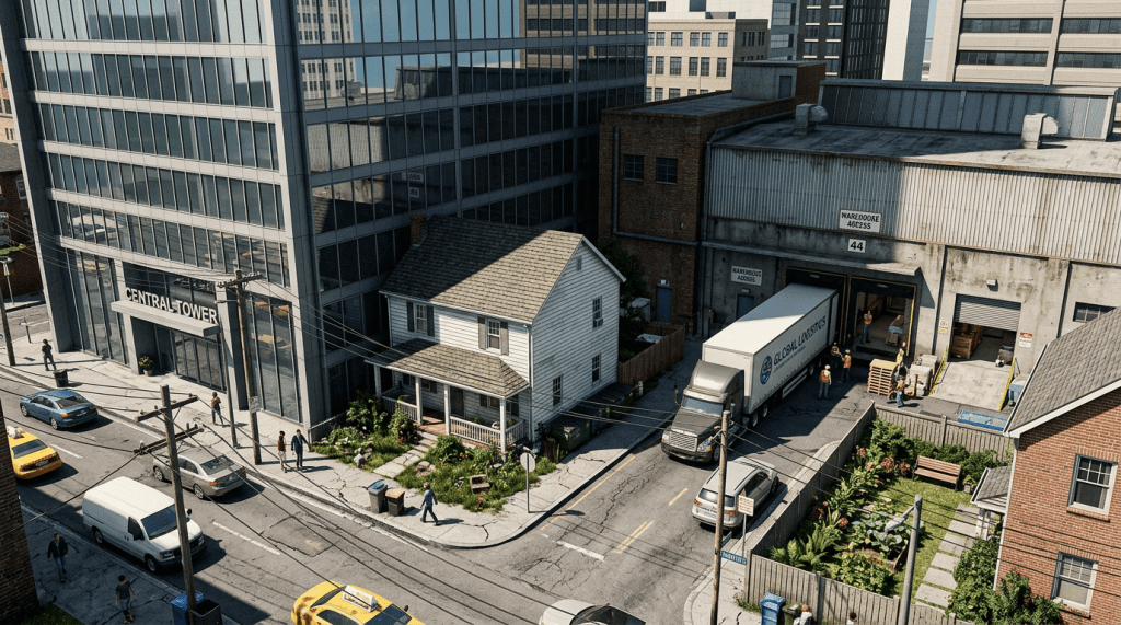
The consequences of a completely unregulated urban frontier
If we were to strip away all land use and zoning regulations, the immediate result would not be a highly efficient free-market utopia, but rather a chaotic and functionally compromised landscape. Without this invisible blueprint, the fundamental certainty that underpins property markets would vanish overnight. Property values would become highly volatile, as an investor or homeowner would have no legal guarantee that a noisy, large-scale industrial facility wouldn’t be constructed on the adjacent block the following week. This heightened risk would likely deter long-term investment, stalling development and destabilising local economies.
The most immediate physical crisis would be the widespread failure of urban infrastructure. City planners currently rely on zoning maps to predict population density and commercial activity, which directly informs the dimensioning of water mains, electrical grids, and road networks. In a deregulated scenario, a sudden cluster of hyper-dense apartment towers or power-hungry commercial facilities in a previously low-impact area would instantly overwhelm local utilities. This would lead to chronic power outages, compromised sewerage systems, and gridlocked transport corridors, as the infrastructure would be completely divorced from the rapidly changing physical reality of the built environment.
Furthermore, the historical imperative of zoning – protecting public health and safety – would be entirely undermined. We would likely see a return to the hazardous conditions that plagued early industrial cities. Heavy manufacturing, 24-hour logistics hubs, or waste processing plants could legally operate right next to residential housing complexes or schools. The resulting noise, air pollution, and constant heavy freight traffic would severely degrade the liveability and safety of the surrounding area.
The physical form of the city would also suffer dramatically. Without regulations dictating setbacks, building heights, or floor area ratios, property owners would be incentivised to maximise the footprint of their land to extract maximum profit. This would lead to monolithic structures built right to the property lines, blocking natural light and airflow, and creating dark, oppressive streetscapes. Coupled with the lack of heritage protections, historically significant architecture would be rapidly demolished and replaced, stripping global cities of their distinct cultural identities in favour of purely utilitarian construction. Ultimately, while current zoning frameworks require deep and urgent modernisation, the complete abandonment of spatial regulation would render future cities deeply unpleasant and logistically unmanageable.
Modernising the regulatory framework
To ensure that cities remain economically vibrant, functionally efficient, and adaptable to future challenges, the regulatory blueprint must evolve. Urban planners and economists globally are advocating for significant updates to how we manage land use, shifting away from prescriptive, single-use models toward more flexible, outcome-oriented approaches.
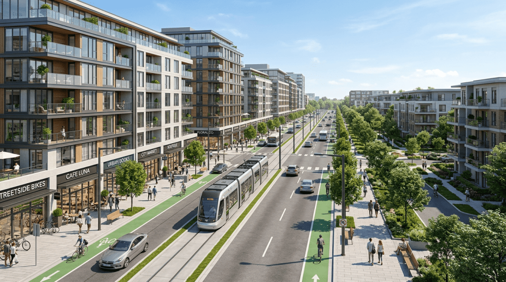
One of the most effective improvements is the widespread adoption of mixed-use zoning. By legally encouraging the blending of residential, commercial, and light-industrial spaces within the same building or neighbourhood, cities can drastically reduce the need for vehicular travel. Mixed-use environments foster “15-minute cities,” where residents can access workplaces, retail centres, and essential services within a short walk or bicycle ride. This reduces traffic congestion, lowers infrastructure maintenance costs, and creates highly active, economically productive urban precincts that remain vibrant throughout the day and evening.
Another vital update is the implementation of form-based codes. Traditional zoning is primarily concerned with the function of a building. Form-based codes, conversely, focus on the physical form of the built environment and its relationship to the public realm. Under this system, a city might regulate the height of a building, its facade, and how it meets the footpath, while allowing the internal use of the building to change freely between residential, retail, or office space based on market demand. This provides immense economic flexibility, allowing neighbourhoods to adapt organically over time while maintaining a predictable and aesthetically pleasing physical streetscape.
To combat housing shortages, cities are increasingly looking towards strategic “upzoning” and the relaxation of density limits. This involves revising zoning maps to permit higher-density developments, such as medium-rise apartments and townhouses, particularly along major transport corridors and around commercial hubs. By removing restrictive single-family zoning and allowing “missing middle” housing, cities can dramatically increase housing supply, ease price pressures, and make more efficient use of existing infrastructure.
Furthermore, the rigid mandates surrounding minimum parking requirements are being dismantled. For decades, developers were forced to build a set number of parking spaces for every new apartment or commercial space, driving up construction costs and encouraging car use. By eliminating these mandates and allowing the market to determine parking needs, cities can lower the cost of development, repurpose valuable land for productive uses, and naturally shift transport patterns towards more efficient public networks.
Episode 433R of the What is the future for cities? podcast illustrates exactly why this regulatory reform is so urgent. Regulatory compliance can add up to $84,000 in hidden fees to a new home, mathematically forcing developers to abandon starter homes and exclusively build luxury properties just to ensure a return on investment. Furthermore, because these density controls legally cap urban core populations, development is violently pushed outward; this has caused the fraction of commuters forced to travel more than 30 minutes to surge from 28% in 1980 to nearly 40% in recent years:
Data-driven zoning and future technologies
Looking towards the immediate future, the administration of land use will increasingly rely on advanced technological integration. The rise of digital twins – highly detailed virtual models of entire cities – allows urban planners to simulate the impact of zoning changes before they are implemented. Planners can model how an increase in density in a specific neighbourhood will impact local traffic patterns, wind flow, sunlight, and the strain on the local power grid.
This transition towards data-driven planning will enable the rise of “performance zoning.” Instead of blanket rules prohibiting certain uses, performance zoning allows any development provided it meets strict, quantifiable performance criteria regarding noise, traffic generation, and visual impact. Powered by real-time data from citywide sensors, this dynamic approach could eventually replace static zoning maps entirely, offering maximum economic flexibility while strictly safeguarding urban amenity.

The future of the global city hinges on an intricate balancing act. Land use and zoning regulations are indispensable tools; without them, our urban environments would descend into logistical chaos and functional inefficiency. However, the legacy systems of the 20th century have proven too rigid, fostering sprawl, artificially inflating housing costs, and constraining economic agility.
Updating these frameworks requires a paradigm shift from micromanagement to facilitation. By embracing mixed-use development, focusing on urban form rather than strict utility, and leveraging technology to monitor real-time urban performance, authorities can rewrite the invisible blueprint of our cities. The goal is no longer just to separate incompatible uses, but to intelligently weave them together, creating dynamic, high-density, and economically resilient urban landscapes capable of adapting to whatever the future holds.

Next week, we are investigating informal settlements!
Ready to build a better tomorrow for our cities? I’d love to hear your thoughts, ideas, or even explore ways we can collaborate. Connect with me at info@fannimelles.com or find me on Twitter/X at @fannimelles – let’s make urban innovation a reality together!

Leave a comment